Join the Network of CoCoRaHS Observers


Interested in signing up for CoCoRaHS? Just want to learn more about the nationwide network of precipitation observers? This post is for you!

For more than 20 years, CoCoRaHS has maintained a network of weather observers across the nation that report critical precipitation totals on a daily basis. The project got it’s start in Colorado in 1998, and has since spread across the United States and into Canada, Puerto Rico, the U.S. Virgin Islands, and the Bahamas. More than 20,000 observers have joined forces to report rain/snow totals in an effort to better understand precipitation patterns in their region.

This network is particularly important in non-urban areas that lack an established ASOS or COOP weather station. In some counties across the United States, CoCoRaHS observers are the only source of precipitation information. Without them, their county could potentially be underrepresented in precipitation studies, a fatal blow to those who rely on rainfall for their everyday needs.

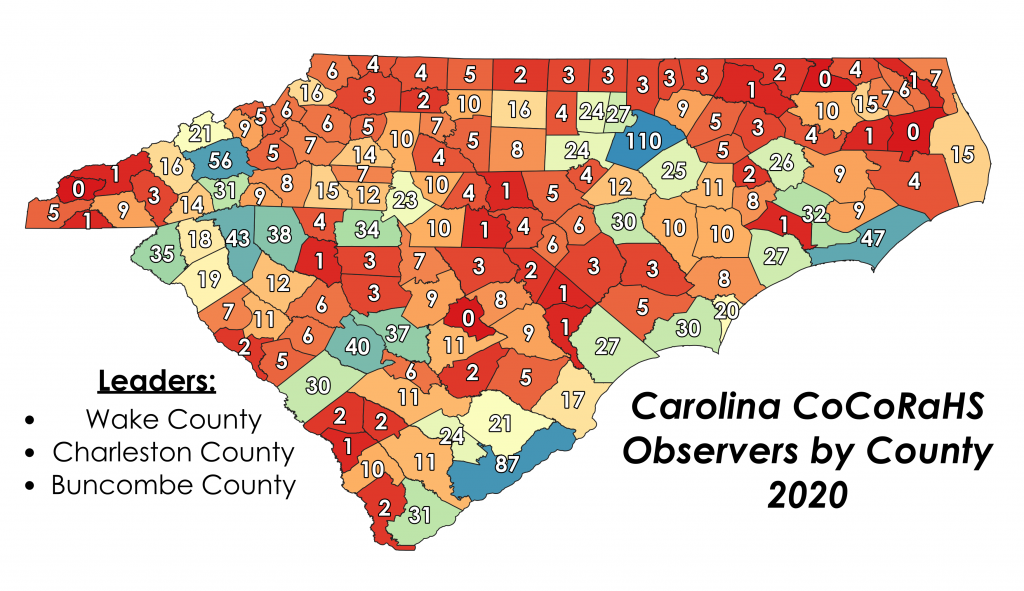
In 2020, more than 1,700 people reported precipitation totals across the Carolinas. Urban areas led the way with the most CoCoRaHS observers (we see you Wake County!), but other counties are in desperate need of more CoCoRaHS observers. Four counties in North and South Carolina had no observers in 2020, and we’d love to see that change this year. If your county is in the list below, it means you are being represented by less than 5 observers. Consider signing up to be an official CoCoRaHS observer for your area! The only equipment you’ll need is a 4″ diameter rain gauge, which you can find here (they’re on sale right now!).

Counties with <5 Observers in 2020

North CarolinaSouth Carolina
Alleghany County, NC
Anson County, NC
Bladen County, NC
Camden County, NC
Caswell County, NC
Clay County, NC
Columbus County, NC
Edgecombe County, NC
Gates County, NC
Graham County, NC
Granville County, NC
Greene County, NC
Halifax County, NC
Hertford County, NC
Hyde County, NC
Jackson County, NC
Jones County, NC
Lee County, NC
Martin County, NC
Montgomery County, NC
Northampton County, NC
Person County, NC
Richmond County, NC
Robeson County, NC
Rockingham County, NC
Rowan County, NC
Stanly County, NC
Surry County, NC
Swain County, NC
Tyrrell County, NC
Vance County, NC
Warren County, NC
Washington County, NC
Wilkes County, NC
Yadkin County, NC
Allendale County, SC
Bamberg County, SC
Barnwell County, SC
Cherokee County, SC
Chester County, SC
Chesterfield County, SC
Clarendon County, SC
Dillon County, SC
Fairfield County, SC
Jasper County, SC
Lee County, SC
Marion County, SC
Marlboro County, SC
McCormick County, SC
Union County, SC


SURVEY: Roof Ripped from Home by Tornado


The National Weather Service in Raleigh has confirmed three tornadoes that occurred during Thursday’s severe storms in North Carolina. No injuries or deaths have been reported as a result of these tornadoes, but several homes were severely damaged with roofs ripped off. Surveys are still ongoing, so all ratings are preliminary.

A long-lived cell dropped the first tornado southeast of High Point at 5:01 PM, blowing down trees and powerlines. Initial reports suggest structural damage occurred near I-85, with major roof damage in the area. It stayed on the ground for roughly a mile before lifting, with peaks winds estimated around 85 mph.

The same cell went on to produce another tornado to the east of Greensboro, touching down just north of I-40. It carved a discontinuous 2.5 mile damage path towards Elon, NC before lifting around 5:44 PM. The initial damage survey found significant tree and roof damage, thus earning the tornado an EF-1 rating.

The last tornado from this cell occurred a little after 6 PM in a remote portion of Orange County, NC. Despite travelling through a sparsely populated area, it managed rip the roof off of one home on Pentecost Road. It has been awarded a preliminary EF-1 rating.

Elsewhere in the Carolinas, scattered reports of wind damage and small hail accompanied strong to severe thunderstorms. A damaged barn led to the deployment of a survey team near Roanoke Rapids, where they found evidence of straight line winds up to 88 mph.

Be sure to check out our updated blog page! Peruse through our old blog posts and bookmark the page so you never miss another post.

Prepare Now! Severe Weather on Thursday

Hi everyone, here’s the latest on the severe threat that’s expected to impact the Carolinas on Thursday, March 18th (yes, tomorrow!). If you have any questions, please tune into our YouTube livestream tonight at 8:30 PM and we’ll be sure to take them.

As of today at noon, the Storm Prediction Center has placed a significant portion of South Carolina, as well as central and eastern North Carolina in a moderate risk for severe weather. Strong to severe storms will begin their march across the state tomorrow morning around sunrise, with western areas being impacted first. By afternoon, daytime heating and sufficient shear will lead to numerous severe storms across the central and eastern Carolinas.

All forms of severe weather are possible, including large hail, damaging winds, and tornadoes. These storms will continue past sunset in the eastern Carolinas, resulting in a very dangerous nocturnal tornado threat.

Now is the time to make sure you and your family are prepared for severe weather. If a warning is issued, you and your family need to know where to go and what to take with you.  Remember a watch means conditions are favorable for severe weather. A warning means that severe weather is imminent/occurring and you need to enact your plan. We suggest you have multiple ways to receive severe weather alerts. Weather radios, apps, broadcast media, WEA alerts, and official sources on social media are great ways to receive severe weather alerts. 

For those interested in following along with real-time ASOS observations tomorrow, go check out our Real-Time Mesonets page! It’s a great way to track the location of the warm and cold fronts as they traverse across the Carolinas tomorrow.

Severe Storms to Threaten the Carolinas on Thursday

Good evening everyone! Here’s the latest on the severe weather threat that will affect the Carolinas on Thursday, March 18th.

As of Tuesday afternoon, the Storm Prediction Center has issued a slight risk (level 2/5) of severe weather for areas along and west of Highway 321 in Western North Carolina on Thursday. This includes Asheville, Boone, Hickory, Statesville, and Winston Salem. 

Further east, the threat level is higher, with an SPC issued enhanced risk (level 3/5) for most of South Carolina, including Columbia, Charleston, Myrtle Beach, and Greenville. This enhanced risk also extends into portions of central and eastern North Carolina, including Charlotte, Greensboro, Raleigh, Fayetteville, Wilmington, and Cape Hatteras.  

There are still some uncertainties with regard to the timing and instability of this system as it movies into the Carolinas. A cold front associated with an upper level low will move through the Deep South Wednesday, producing widespread severe weather across Mississippi, Alabama, Western Tennessee, and Eastern Arkansas.

If we see the storms move into the Carolinas earlier in the day on Thursday, their severity may be limited by insufficient heating across the western Carolinas. Some models indicate the line of storms will move in between midday and early evening. If this solution pans out, we will see scattered to numerous severe storms. 

Much of this forecast hinges on the amount of instability that will be present in the atmosphere as the storms arrive. Cold air damming will retreat north through the Carolinas on Thursday, allowing for a thinning of the clouds in many areas. This will lead to the development of ample instability over the Carolinas and produce strong to severe thunderstorms. We will continue to monitor the latest model solutions and clarify the exact timing and instability as we approach Thursday. 

All modes of severe weather will be possible. This includes damaging winds, large hail, tornadoes. Sufficient wind shear and cold air aloft will allow for the development of large damaging hail in some storms. Significant wind shear will lead to rotating updrafts in established storms, potentially offsetting the lack of instability to a certain extent. 

Now is the time to make sure you and your family are prepared for severe weather. If a warning is issued, you and your family need to know where to go and what to take with you.  Remember a watch means conditions are favorable for severe weather. A warning means that severe weather is imminent/occurring and you need to enact your plan. We suggest you have multiple ways to receive severe weather alerts. Weather radios, apps, broadcast media, WEA alerts, and official sources on social media are great ways to receive severe weather alerts. 

Join us Wednesday night on the Carolina weather group as we breakdown the latest severe weather threat.

  • Scotty Powell, Associate Producer

“Couldn’t Make it to Top, Wind Gauge Destroyed”


While the blizzard of a lifetime raged on the morning of March 13, 1993, the weather observer on Grandfather Mountain made a daring attempt to reach the ranger station to take his usual daily measurements. That day, however, was far different from any other day he’d experienced on the mountain. An area of low pressure was lifting out of the Gulf of Mexico, dumping feet of snow along the spine of the Appalachians and creating a near-perfect high wind setup. The observer never made it to the summit that day, turned away by the most extreme winter conditions in generations. As such, no meteorological observations were taken. Winds likely exceeded 125 mph, with localized gusts > 175 mph along the rocky ridgeline of Grandfather Mountain State Park. Nearby Mount Mitchell reported a unbelievable 50″ of snow between the 12th and 14th of March, making it the snowiest 3-day period at any North Carolina observation station.


Some of you may remember the Blizzard of ’93, dubbed the “Storm of the Century”, while others have heard stories of the supposed twenty foot snowdrifts and 100 mph winds. Sure, some of those stories were exaggerated, but you’ll find some incredible nuggets of truth if you look back at the meteorological records. Winds didn’t exceed 100 mph in the valleys, but locations above 4000′ really did endure gusts beyond 100 mph on the morning of the 13th, causing widespread damage and power outages. A COOP observer a few miles from Asheville reported a max gust of 101 mph (estimated to 105-107 mph) at 4300′. Snow totals in the Boone area were around 3 feet, so it’s possible drifts reached to the tops of single story buildings. Other outlets have written summaries of this event from the humanitarian perspective, but I want to focus on the weather observations that defined the Storm of the Century in the Carolinas.

The footprint of 18″+ snowfall totals across Western NC is one of the largest on record, with totals exceeding 4 feet on mountains such as Mt. Mitchell, Clingmans Dome, Mt. LeConte, and Roan Mountain. It’s still the biggest snowstorm on record in Asheville and Boone, with 18″ and 30″ 3-day totals, respectively. Along the coast, warmer temperatures kept the snow at bay, but precipitation totals ranged in the 1-3″ range, with isolated totals exceeding 4″. Widespread gusts between 50 and 70 mph were reported in the warm sector, with a gust to 93 mph on Fryingpan Shoals Tower Light Tower off the NC coast.


If you’ve never taken a jaunt through the original COOP forms on March 13, 1993 in the Southern Appalachians, I highly recommend checking them out and reading the fascinating meteorological accounts of COOP observers. Two forms have always stuck out to me for their vivid descriptions: Swannanoa 2 SSE and Grandfather Mountain. The words “Couldn’t make it to top, wind gauge destroyed” ring in my head this time of year. I can’t image the ferocity of the wind on Grandfather Mountain throughout the storm to destroy such hearty anemometers. Likewise, 100+ mph winds at the Swannanoa 2 SSE station were catalogued in delightful detail on the original form.


Do you have a story from the Blizzard of ’93? Share it with us on Facebook or Twitter, or send us an email at carolinawxgroup@gmail.com! We’d love to hear from you.

Why the National Weather Service is Ending “Advisories”


The National Weather Service has decided the hazardous weather bulletins currently known as “advisories” will be discontinued as early as 2024. The decision comes as a result of a multi-year initiative called the NWS Hazard Simplification Project, where meteorologists, social scientists, emergency managers, and others are trying to find a way to simplify the government-run weather service’s massive bulletin library.

The information currently distributed as advisories, such as winter weather advisories, will still be transmitted through what the NWS is calling “plain language text.” In other words, the notifications about potential weather hazards will still be distributed but they will not be categorized as advisories.

Currently, an advisory is one of the three main types of weather bulletins and are issues in conjunction with watches or warnings for severe weather.

The project is being headed up by Eli Jacks. As seen in this clip, he appeared on the Carolina Weather Group in 2019 to explain the project’s goal to simplify their products and reduce public confusion.

WATCH THE FULL SHOW: https://www.youtube.com/watch?v=jdSVhXr9G_A

Very High Fire Danger in the Carolinas

After February’s incessant drizzle, we were all hopeful for a drier March. Unfortunately, we’ve catapulted into a stretch of dry weather that’s nowhere near ending. Some locations across Western North Carolina haven’t seen rain in a week, and it could be another five days before rain chances return.

An unusually dry March airmass is entrenched over the area, and some counties have been placed in the “Very High Risk” category on Monday. According to the NC Forest Service, fires within very high risk areas will start easily from all causes and immediately after ignition. They will spread rapidly with increasingly intense hotspots. Spot fires are a constant danger.


We did an interview with the NC Forest Service last year, covering everything you need to know about fire safety and hazardous fire conditions. You can check it out below for information!


Many locations have dropped below average on their year-to-date rainfall since this dry stretch began. We all remember the big fires of October and November 2016, when more than 50,000 acres burned during a particularly dry stretch of weather. We recommend refraining from burning over the next few days in the Carolinas. Let’s band together and practice fire safety so we never have to go through a wildfire outbreak again.

The Winter of Close Calls


Let’s start with some trivia… What’s hot, cold, wet, dry, and depressingly dark?

If you said “winter in the Carolinas”, you got it right! We’re offering free spring passes until June, get ’em while they’re not too hot!

In all seriousness, meteorological winter just wrapped up, so I wanted to do a quick review of everything we’ve endured and enjoyed over the last few months. A quick shot of cold and light snow in the mountains of North Carolina on December 1st gave way to a relatively mild couple of weeks leading up to Christmas. That was fairly status quo, I think we’ve all grown accustomed to warmer-than-average Decembers in recent years. This year, however, the western portion of the Carolinas shook things up with a beautiful snowfall on Christmas Eve. It was a real treat in the midst of 2020’s insanity, especially as a few snow showers broke containment on Christmas Day and drifted into Central and Eastern North Carolina. It was the first (low elevation) White Christmas in Western NC since 2010.

Fast forward to New Years Day, and the Carolinas were divided by the seemingly ever-present “wedge”. Cold-air damming led to cool temperatures and heavy rain in the Piedmont and Foothills of NC, but the Lowcountry of South Carolina sky rocketed into the upper-70s and low-80s. Charleston, SC recorded its warmest New Years on record, with a balmy 80°F observation at the airport around 1 PM.

January never got too warm, but it also never got too cold. Afternoon highs were close to normal across the Carolinas throughout the month, but nighttime lows continued with the multi-year trend of staying above average. A major system rolled through on the 8th, breaking the hearts of thousands of snow lovers across Western NC. Forecasted snowfall totals of 4-8″ in the Asheville area never materialized, and some places saw less than half an inch in the central French Broad Valley. We can be honest, that one hurt a bit. It’s never fun getting a forecast wrong, but we learn from each mistake and apply that knowledge to future events. There were areas where the forecast verified, with totals in the 4-8″ range across the Foothills and High Country of Western NC. Flakes flew as far east as the Pamlico Sound, with light accumulations around Greenville, NC. Another moderate snow event impacted central and eastern NC on the 27th and 28th of January, bringing several inches of snow to locations north and east of Raleigh.

February was the needle that almost broke the figurative camel’s back. Cold-air damming led to a series of back-to-back ice storms across the northwestern Piedmont of NC, causing tens-of-thousands of power outages and significant tree damage. A lot of us didn’t see the sun for 10+ days, and you could count the diurnal range on one hand. The first three weeks of the month were some of the dreariest in recent memory… Thankfully, the “wedge” finally broke on the 23rd, and seasonally warm temperatures dominated the last few days of the month.

All in all, it was a decent winter for those who like cool weather. We didn’t have any major snow storms on the order of 12″+, but numerous events brought flurries into Eastern NC, and one event dropped grapuel all the way to Charleston, SC. Temperatures were mostly below normal, and snowfall totals varied across the state. One thing that I haven’t mentioned is the well-above average precipitation totals, particularly in the eastern part of the region. Several stations broke all-time winter precipitation records in the Raleigh area, where 15-20″ of rain fell in the months of December, January and February.

As we head into meteorological spring, we’re hoping for mild weather and no severe weather. Unfortunately, we rarely get what we want when it comes to the weather, Mother Nature does as she pleases. Keep an eye out for the occasional cold outbreak, and remember that freezes can occur as late as May in parts of the Carolinas. Good luck to everyone as we enter the second annual “I swear it’s allergies, not COVID” spring season. Pollen counts are already spiking, so buckle down on your favorite allergy medicine.

Lastly, we’ve got some exciting news to share in the next few weeks! We want to make the Carolina Weather Group more collaborative and open to community involvement, so be listening for a big announcement!

Weather Highlight: February 27-28, 2021 Undercast


February felt like an unending stretch of cold, cloudy days as many folks across the Carolinas were stuck beneath the dreaded “wedge”. Quasi-stationary high pressure over the Northeast drove a moist, low-level airmass up against the eastern side of the Southern Appalachians, and it just wouldn’t go away. If you felt like it was abnormally cloudy and rainy last month, you would most certainly be right. While each winter (and many summers) feature cold-air damming events, this February stood out as one of the dreariest in recent history.

There were some warm, sunny days, but you could probably count them on one hand. When compared to February 2020, average temperatures were a category lower this year, thanks in part to the persistent cloud cover. For a quick visual, check out the slider tool below to compare temperatures in February 2020 and 2021.


The last two days of February featured some wild temperature variations across the western portion of the Carolinas. As the “wedge” began to break up, locations above 2800′ and west of the Eastern Continental Divide were suddenly thrown into full sunshine.

On the afternoon of the 27th, I travelled to an isolated location along the Blue Ridge Escarpment, and suddenly found myself standing a few dozen yards above the top of the clouds. Cold-air damming was still holding strong across the foothills and piedmont of NC, but I the higher elevation of the Escarpment let me escape the dreary conditions below. I was gazing out over a sea of undercast, one of the most surreal weather phenomena in the world, in my humble opinion. A sheet of white clouds extended before me all the way to the horizon, and I was basking in full sun with temperatures near 80°F.

If you haven’t heard it said before, the atmosphere behaves like a liquid, and waves of clouds broke against the Blue Ridge Escarpment that afternoon. Every now and then a cloud wave would wash up over me, and temperatures would fall 20+ degrees in a matter of minutes. It really was an ethereal experience, and one that I would highly recommend as we begin Spring.

You can see some time lapse footage that I shot below. The quality isn’t the best, but it gives a visual demonstration of the atmosphere sloshing about. There’s also some clips from sunrise on the 28th, when the cloud level was much lower and more akin to fog.


If you’re interested in the meteorological conditions that lead to impressive displays of undercast in the Southern Appalachian Mountains, stay tuned for another blog post coming soon. I’ll dive into what I look for when I forecast these events, and even a few of the locations that I visit for maximum visibility.

I hope we all see a bit more sun in March!

Evan

Sign-Up for Free Storm Spotter Training


Join the network of trained weather spotters across the Carolinas!

The Carolina Weather Group is hosting free SKYWARN Storm Spotter training with the National Weather Service Office in Columbia, South Carolina on Fri., March 26 at 6:30 p.m.  

Everyone from across the Carolinas is welcome. (You do not need to live near Columbia to join our class.)

The class is free and will teach you all you need to know to submit priceless storm reports to the U.S. National Weather Service (NWS) nearest you. 

Storm spotters are not storm chasers. They’re not asked to do anything dangerous nor are they asked to travel. The National Weather Service wants to know what’s happening where you live in order to get a street-level view of real-time impacts. When severe weather strikes, your eyes and ears will become an extension of the NWS. You’ll play a part in their mission to protect life and property.

A meteorologist from the NWS will be presenting this “Basic” class, the first of three tiers offered by the National Weather Service. Join the Carolina Weather Group for this virtual training by pre-registering now at https://bit.ly/3bR3VtS

Want to continue on to the advanced or radar class? Can’t make it on Friday, March 26 at 6:30 p.m.? Below are links to help you find additional classes and different times.

NWS Columbia, SC: https://www.weather.gov/cae/skywarn.html

NWS Greenville-Spartanburg (Greer, SC): https://www.weather.gov/gsp/skywarn

NWS Raleigh, NC: https://www.weather.gov/rah/skywarn

NWS Newport / Morehead City, NC: https://www.weather.gov/mhx/MHXSkywarn

NWS Wilmington, NC: https://www.weather.gov/ilm/skywarn 

NWS Charleston, SC: https://www.weather.gov/chs/skywarn

NWS Roanke (Blacksburg, VA): https://www.weather.gov/rnk/skywarn

NWS Wakefield, VA: https://www.weather.gov/akq/SKYWARN